Snowfall Potential: January 21st & 22nd 2018
Hi all- a Winter Storm has it’s sights on the Upper Midwest for the late weekend and into the early work week.
Here’s what we know:
- Someone has potential to get a lot of snow: What is a lot? Anywhere from 6-12″ or more.
- This storm will come out of the Rockies: Bringing out ahead of it- a lot of warm air- which we are currently experiencing.
- Afterwards: We cool down again.
- The snow will be HEAVY: Heavy wet snow- aka ‘Concrete Snow’
What we don’t know, yet:
- The exact track of the system: This will be one of those situations where the track of the low is crucial because warm air will be such a huge factor in this storm.
- How much dry air will get wrapped into the system: The dreaded ‘dry-tongue’ has potential to make an appearance on this one.
- How much mixed precipitation will fall: As always- mixed precipitation can impact snowfall totals, significantly, resulting in Boom or Bust scenarios.
Here are some maps, charts and fun graphics for your viewing pleasure:
Also- a general reminder- anyone posting totals maps this early on- it’s generally a huge risk, as so much can change. For anyone that does take the risk, just know that outside of 48 hours, a lot of error potential exists.
**For the purposes of demonstration- I will show the Euro and NAM here- but there are so many more to consider, but I could take screenshots all evening. The GFS shows similarities also**
__
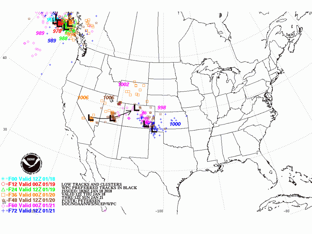
Surface Low Tracks:
Here is a chart showing potential areas where this low could eject out of the Rockies/Colorado. It is a Day 1-3 Graphic, so beyond that, it isn’t showing much yet, in terms of potential tracks.

NAM from Tropical Tidbits: GIF of storm potential…

The heaviest snow tends to fall where 850mb temps are about -2 to -6 Celcius:
Euro Model:

NAM:

Moisture advecting towards the low:
Dewpoints will be near 50-55F as close as Central Illinois. This will help bring more moisture into the system.
Euro Model:

NAM:

Relative Humidity:
Needs to be above 90% between 1000mb and 500mb in the atmosphere.
1000 Mb:
Euro Model:
The white- as you can see on the legend represents nearly 100%


925Mb:
Euro Model:
The white- as you can see on the legend represents nearly 100%
NAM:
850mb:

NAM:

700mb:
Euro Model:

NAM:


500mb:
Euro Model:
This one shows some dry air trying to work into the system at the mid/upper levels…

NAM:
Jet Stream:
A couple of Jet Streaks depicted on this map, with general areas of lift, circled in red. The lift helps aid convection and precipitation formation/moisture condensing into clouds.
Euro Model:


NAM:
Overall- a lot to watch with this system. Generally- anyone throwing out large numbers in advance is hyping up the storm. Realistically, I can see some totals maps starting to roll out tomorrow that may have a touch of decency with them. But remember- this storm is still off the CA coast- and has a long way to go- over 2000 miles. Friday evening into Saturday should reveal A LOT more about this storm. For now- I will post this graphic again for the general area that really could see a solid storm.
For General Radar, Extended Forecast Details and Current Conditions, don’t forget to download my app!
BoKnowsWeather App–Available for iPhone and Android on App Store and Google Play Store
As always- don’t forget to follow me on Twitter @BoKnowsWeather and Instagram @BoKnowsWeather also….
COMING SOON– my new website. So stay tuned for updates on that. I was hoping to have it up by now, but I’ve been so busy at work, that I have had trouble wrapping it up in time.
Thanks for checking in.
-Meteorologist Bohdan Cole


