Two storm chances next week–changes likely in forecast!!
Hello-
The models have been hinting at two large storms next week–or, what we are really seeing is the likelihood of one large storm in multiple waves, split up like two separate storms. These are generally impulses that spin up off of the main low pressure center—so we usually see multiple waves. This is fairly common of large storms of this nature.
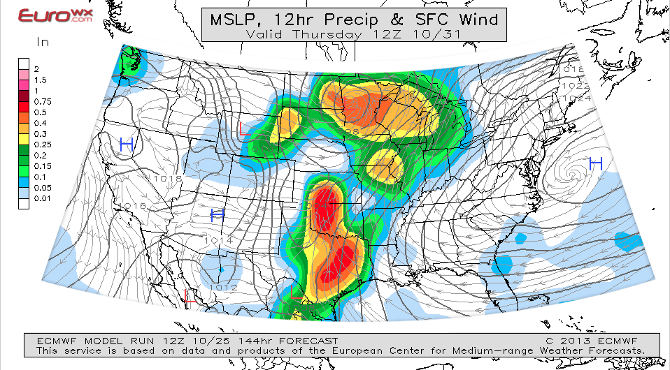
The ECMWF runs yesterday were pulling the brunt of the storm over MN near Halloween, with a preliminary part of the storm on Tuesday. Now, the normally reliable ECMWF seems to pull it further away on Halloween and after.
Another very significant aspect of this storm system is that we may see multiple severe weather outbreaks to the south, over Kansas, Oklahoma, and East into the Deep South/Dixie Alley area.
The ECMWF (European Model) seems to keep most of this storm warm, with the Metro being in the warm sector to the east of the low pressure area around Halloween. The GFS seems to pull the storm farther to the south initially, which would put us in a more favorable position for snow, instead of rain…but then it warms back up near Halloween, even though we are in proper range/distance from the low, to be in the position for snow (if it were cold enough). Another significant aspect and changing variable to this storm system is the timing of storms arrival. At night, this time of year, we typically see cold lows, and especially lately, some sub-freezing lows. During the day, we usually moderate. Whatever ends up falling at night has a higher chance of being snow.

ECMWF Storm Wave 1
The GFS seems to hint at the storm being a little bit colder for MN–meaning a greater snow potential during the initial wave on Tuesday. After Tuesday, even though the low is just to our SE, the model seems to hint at a lack of cold air. I image this will change as the models evolve in the coming days:

GFS Initial Storm Impulse
This map shows us being very close to the blue 540 (freezing) line, which could mean a mix of rain and snow. The next map shows a secondary impulse of the storm coming through, but conditions seem to be a bit warmer during this phase. The low is in the “typical” proper position to get us some snowfall, but this chart seems to indicate a lack of cold air. I have a feeling with a storm this large, things could change, and more cold air could end up coming into the system. From what I have been reading, this storm is showing some similarities to the Blizzard of 91′. The only difference here is the lack of truly cold air–for now. I will keep an eye on this storm, as it is worth watching for sure. The many waves of it, and abundant precip & extreme temp contrasts to the south will likely make this storm a beast. If we get enough cold air–I might be scared of what we could see. This is all just a figment of the computer imagination though. On Sunday, things should become much more clear as the storm comes on shore and moves thru the Mountains–ready to re-form to the east, near us.

Secondary Impulse of Storm

Temperatures during Initial Phase of Storm
The temps (above) certainly indicate some cold air nearby with the GFS model. The dewpoint map below from the GFS also shows a strong contrast to the south, which could fuel some severe weather.

Dewpoint Temperatures
Strong jet stream winds always play a huge role in storm formation and strength, and we seem to have a lot of that here as well!

A lot of Jet Stream Energy
As mentioned, this storm will evolve on the models over the next week, and it might miss us entirely. The one thing that is becoming increasingly common on all of the models is the fact that most of them are picking up on this storm forming in the mid section of the country–and being a very large storm. A lot of precip and severe weather will be likely in many areas–including us here in Minnesota (rain and thunder nearby). The one question that remains is how much cold air wraps up into the storm, and the overall speed of the storm. The common theme is size, as models seem to indicate this. The models seem to break it into several phases now, with a couple of impulse low pressure areas spinning off of the primary low–which is quite common with large storms as they ramp up, East of the Rockies. The mountains tend to really unravel these storms before they piece themselves back together.
Stay tuned to this blog, and my Twitter account @BoKnowsWeather, and Facebook: www.facebook.com/boknowswx. Also check out www.rebelmouse.com/boknowsweather. I will be providing updates with each model run through the weekend and into next week. From Tuesday through Next weekend, we have a few chances to be under the gun. Stay aware!
Thanks for visiting!
Bo


