Update on Severe Weather Expectations Today
SEVERE WEATHER POSSIBLE TODAY!!! See below for an extended write up!
Hello-
If you checked in several days back, I had been talking about some severe weather possibilities for this weekend. Here we are on the day this event is supposed to happen.
Just last evening, the SPC had put out a 10% probability of Tornadoes in IA & E NE, and 5% for Southern MN. That refers to the odds of tornadoes in the vicinity of any given point based on mileage. Anyways–that number has since been reduced again today.
A couple of things I am noticing today:
-Some storms are forming in West Central MN as of about 1 hour ago, and it is currently 12:30pm Central. With the latest trends, I expect that this line may grow and merge with some new cells and move thru MSP. It may even intensify and bow out as it heads thru Wisconsin.
On the back side of this, and to the South, there may be some more activity in SE SD, and Nebraska, as well as Iowa and Kansas. Late in the evening, there may be some additional activity that forms over S MN from leftover cells that merge, and we could be in for some very heavy rainfall overnight as well.
I will post some images to help tell the story a bit better.
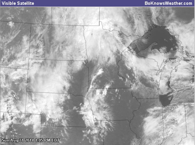
Here is the current visible Satellite at 12:30pm Central:
You can see the brighter white band from SW MN up to just near Central MN, as that line of storms expands.

VIS
Here is the current radar from RadarScope for Mac, and it shows that the thin line is solidifying to the West:

Current Radar
What seems to be happening now is that the cold front is “catching up” to the warm front, which essentially means the front is occluding.
Here is a surface map to show what I am talking about:

Surface Map
On the Northern Edge of that Warm front, we have a relatively abrupt boundary of CAPE (Convective Available Potential Energy), seen here is this image below:

CAPE
Next up are some ‘fun’ little charts I like to look at on the SPC Forecasting tool. They usually are beneficial in ‘day of’ situations where storms are imminent or forming. It gives a better snapshot of the situation. Below are the Supercell Composite, followed up by the Significant Tornado Index. It isn’t off the charts, but it shows as this line heads East, we may be looking at some intensification before the next possible batch moves in this evening.

Supercell Composite

Sig. Tornado Index
Seeing the charts today, it is painting an interesting picture. It seems we have some old convection leftover from last night that somewhat maintained, in Nebraska, South Dakota and even Iowa. Some of that stuff may re-intensify, and then be mixed in with newer cells. I think this is the reason that SPC lowered the Tornado risk back down, because everything will likely converge into a big “HP” (High Precip) mess at some point, minimizing the risk of discrete cells–which is usually where you see the strong tornadoes. This isn’t ruling them out completely at all, as the odds are still there, but I do think there may still be a reduction in overall Tornado activity. There should be a lot of activity to the South that will help merge into a heavy rain/isolated severe situation for Southern MN and IA overnight, and into Wisconsin and Illinois.
I don’t normally rely too heavily on Simulated Radar–but I think it is mostly a fun way of showing how things “may” evolve in time. It is never perfect, as most models are not the best at handling convection and tend to over develop etc, and the whole run can be thrown off. Based on how this one is starting out with the HRRR model (a short-term High Res model)–I think it may be helpful to show.
The first is roughly 1pm, which shows the storms to the West of MSP.

1 PM Simulated Radar
A bit later on, coming in at 3pm here: Showing possible storms on the doorstep of MSP.

Simulated Radar
Progressing on to the 6pm hour here: This shows the line has passed into WI and even intensified a bit. Overall activity to our SW showing some discrete cells mixed in with leftover convection that re-intensifies.

Simulated Radar
Next up is the late evening time frame at 9pm: Much of the activity to S is starting to merge into separate clusters. Relatively quiet for MSP at this time it would seem.

Simulated Radar
Now we advance up to Midnight and just after at 1am: This shows some new activity forming primarily on E side of MSP and much of S MN, causing heavy rain and localized flooding (I anticipate). This chart also hints at a Bow Echo MCS heading for Kansas City–possibly producing widespread wind damage if it occurs.

Simulated Radar
Last up is about an hour and change later, showing a similar pattern unfolding, which shows me the storms may be “training” and moving over the same area like train cars.

Simulated Radar
Since I have been wrapped up in writing this post, I will take another look at radar and the SPC site to check for warnings….
Just a moment…
Ok–no warnings or watches yet or anything. There may be a watch issued for the NE US, in the secondary area for Severe Weather.
Here is another look at Radar, and also some of the SPC advisory criteria for today.

Updated Radar
Slight Risk of Severe Weather today:

Slight Risk
Tornado Risk today:

Tornado Risk
Damaging Wind Risk:

Damaging Wind Risk
Large Hail Risk:

Large Hail Risk
Overall, I don’t think there will be as much severe weather today as was prior anticipated. You’ve heard that before, right? Well–after this mid afternoon to late afternoon round of storms, the primary risk tonight will be torrential rain, especially in SE metro and S MN. The main risk of tornadoes should stay South. I am interested and curious to see how this line to the West of the Metro evolves with time as it moves into a ‘relatively’ more unstable environment according to latest values on the SPC site. It’s still worth watching, and I will be doing that all day. Stay tuned to Twitter for the most frequent updates. A majority of my posts on there will also go to my Facebook page. Details below.
My little disclaimer here—On a side note–simulated radar activity above is just a guide of possible options, and NEVER a guarantee. Also–please take my writings as merely an opinion, and be sure to stay tuned to local watches and warnings and take all of them seriously if they do come in. There are others that have more time in the business and may have a better handle on things. The situation could change completely and the timing is just an approximation. Variables can change thru the day and new storms may form, and other things–so be sure to have a secondary plan in place all day, and a proper place to take shelter if storms do come up. I appreciate you checking in!
Stay with me on Twitter @BoKnowsWeather (twitter.com/boknowsweather) and Facebook (www.facebook.com/boknowswx)–Please like the page and follow if you haven’t already. Also, my site has live radar and other forecasting tools that you can use for Free. www.boknowsweather.com
Thanks for checking in!
Bo
PS–please forgive any typos or grammatical errors. Trying to put this out fast before the weather changes too much given the expected conditions.–and didn’t look too closely after I wrote a majority of it.
Sources for today’s info:
www.boknowsweather.com
www.spc.noaa.gov
http://www.hpc.ncep.noaa.gov/
RadarScope App (Phone & Mac Computer)


