First shot at Severe Storms on Sunday
Hey everyone-
I hope you’re enjoying Spring so far. It seems pretty typical for MN to me. Random warm streaks, followed by cool–all of the stuff that often makes us question why we all live here. Don’t worry–we should be thru that soon enough.
The streets have been swept and neighborhood gardens planted–it has to stay warm now, right? :)
The first shot at ‘Marginally’ Severe storms could show up for Southern MN tomorrow (Sunday 4/24). Just enough humidity creeping up along a warm front, and enough dynamics nearby to create some potentially severe storms. The risk is greater as you head down into IA, NE, KS and the central plains. The plains is also gearing up for a potentially big week as a trough sets up over the rockies.
Let’s dive in with some graphics…
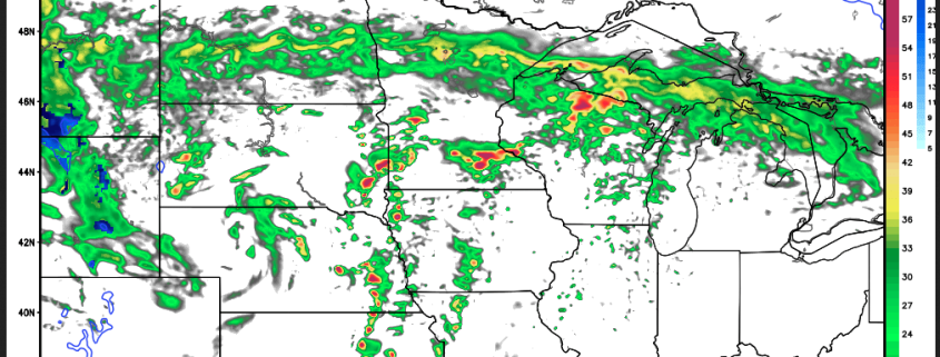
Since we are not quite in range of ‘future visibility’ on models with the high res HRRR, we have to look at the NAM4k. Also–take the Simulated Radar with a grain of salt–but here’s what is shows for just around the dinner hour on Sunday.
Leading up to this, we have a chance of showers and storms this evening, and into the day Sunday, with some breaks expected. Then in the late afternoon, some more ‘stronger’ storm development seems likely.
The warm front looks like it will park itself right over MSP–as depicted with the strong temp gradient, and moisture (dewpoint) gradient right over MSP…
Temps:
Dewpoints:
Also–any CAPE won’t show its face until later–and again, pretty much cuts the metro right in half in this model run. Things could still change of course…
Lifted Index–supports storm development just over and South of MSP currently:
A few more for you here…
The Supercell Composite and Sig. Tor parameters… nothing too crazy here in MN–except a slight bit S on I-35 near say..Northfield or so–up into Red Wing area…perhaps we could be in store for a few surprises tomorrow in S MN.
And finally–Updraft Helicity, which can be an indicator of where rotating updrafts may be. It’s tough to say this far out, but it is still fun to look at at consider. So–as you can see, the brunt of the action stays South, but we could have a few surprises in So. MN if things stay like they are looking right now.
Currently the SPC has us in a Marginal Risk of Severe Weather, with a Slight Risk, just South of us:
Stay tuned for updates as new model data comes in. The possibility is there for the warm front to move further North, or stay South–leaving us cooler in MSP..or warmer. It can also shift the whole focus area for storm changes. Stay alert for rapidly changing conditions in parts of Southern MN. This is the time of year where the storms can really creep up on you as we enter Severe Weather season.
Thanks for checking in…
-Meteorologist Bohdan Cole

