Outlook for MN: First Snow Chances
Hello-
You have probably been hearing of snow chances on your local news forecasts… and yes, it is looking more and more likely.
Change happens quickly in Minnesota this time of year. We can go from late season severe weather to early season snowfall like the flip of a light switch. For those of you that didn’t know, South Dakota and Wyoming have already been blasted by some early season snowfall–measured in FEET. Some places got upwards of 4 or 5 feet, with drifts that buried homes, and killed over 100,000 animals/cattle. We won’t see anything like that, but the first couple of snowfalls always seem to generate some buzz–and certainly some unwanted excitement on the roads.
The computer models are still having a tough time with this forecast–but the main issue this time of year with predicting the snow you have likely heard about is–warm ground temperatures, and ‘relatively’ strong daytime sun. If precip falls overnight when temperatures drop, then it is much more likely we will see snow. So, in this case, and likely through the end of the month, it will be all about timing. There will be a lot of cold air from MSP and out to the Eastern Seaboard as the pattern changes. As we get closer to the end of the month, it may even be cold enough to have snow during the day, and for some of it to stick. Anything that does fall on Sun/Monday will likely melt right away.
Either way, I think it is time to prep the house for snowfall/winter, and to winterize the car, clean the yard, and get the snow tires ready to be put on–if you use them. The transition appears to be here and likely to happen earlier this year, based on a large dip in the jet stream that will provide ample amounts of cold air. Any moisture that meets that cold air will likely mean a cold rain or early season snowfall.
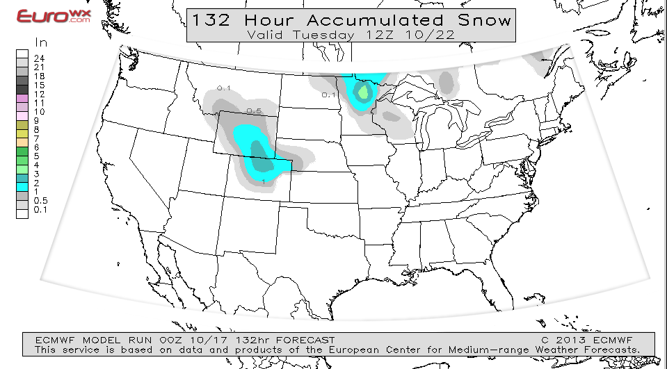
Here is the usually highly reliable European Model from EuroWX.com showing some light accumulations in the area through Tuesday.

ECMWF Outlook from EuroWX.com
Here is the NAM Predictive Radar showing some snow beginning to mix into the rain in Northern and Central MN on Sunday. On Monday we will likely see a transition to more snowfall. I will continue to monitor this as we move through the next few days. There is a potentially a larger storm farther out in the future that looks to be more promising for snowfall if the models hold. It will be worth keeping an eye on. The models have not generated the next images yet, beyond this 81 hour time stamp.

NAM from WeatherBell.com

NAM for Early AM Sunday w/Temps in 20’s
The map above shows temps in the 20’s for the early AM on Sunday. The next image shows temps climbing during the day. The Temps are expected to drop even lower for Monday.

NAM Sunday Temperatures
This is the ECMWF 240 Hours out, showing some precip in the sub-freezing area North of the blue dashed 540 line, which usually translates to snowfall. This is roughly October 27/28th:

ECMWF 240 HR
Here’s the pattern shift we are expecting with the Jet Stream, which will allow colder air to pour down over us.

Late October Pattern
The result of that pattern change is a cold core of air that will settle in over us, and have a far reach, all the way down to the SE US.

Cold Core of Air
Here’s a map showing the timing of the snow showers as they approach MN.

Timing the Snow Showers
Here’s the 7 day outlook for our area, and then the 8-14 day outlook highlighting the possible snow on Oct 27th that I spoke of:

7 Day Outlook
The 8-14 day outlook, highlighting that next chance of snow. It is a long way out, so stay tuned.

8-14 Day Outlook
Stay tuned for updates, and thanks for checking in!
Don’t forget to follow me on Twitter: @BoKnowsWeather and on Facebook: www.facebook.com/boknowswx
Check out my Rebel Mouse page as well: www.rebelmouse.com/boknowsweather
Bo


