October 1st through October 6th: MSP Forecast
Hello-
I am back to blogging here. There has been a long gap due to my busy schedule. I will try to stay on top of this more.
This is a blog you need to read! Chances for Tornadoes, Severe weather, and SNOW?!?
We have a diverse storm system moving in this week, and it looks like it will be a very large one. Severe weather, strong tornadoes, damaging winds, and early season snowfalls are all a part of this storm that looks like it will approach our area Wednesday Evening and last through Saturday/Sunday.
We will see mostly Rain here in MSP–with possibly a lot of it. We need it, so that is good. To our immediate South and East, we could have a risk of Severe Weather on Friday. Saturday and Sunday, there may be enough cold air wrapped into the system to bring some early season snow to Western MN, the Dakota’s, and Northern Nebraska.
Here are some images to highlight the current setup–mainly highlighting Friday and into the weekend for the Severe/Snow setup:
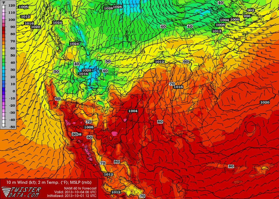
Temperatures: Temperatures will be high enough to allow the formation of storms. A couple of days later, the cool pocket over Montana will expand and move East, allowing for the chances of snow we have been talking about.

TEMPERATURES
Dewpoints: Dewpoints will be in the humid territory for areas S and E of us.

DEWPOINT MAP
Jet Stream Winds: The Jet Stream is looking like it did in May, when we had a good number of severe weather outbreaks, especially in the Southern Plains.

JET STREAM WINDS
Wind Shear: The different color arrows, from different directions indicates the elevated wind shear, which will help initiate rotation in some of the storms.

WIND SHEAR
CAPE: CAPE Values are elevated in the area, which should help to fuel the storms.

CAPE
Lifted Index: Not extreme, but the values are still pretty high for October standards in the Northern Plains.

LIFTED INDEX
Severe Weather Projections from the Storm Prediction Center: This far out, they generally don’t get into specifics, but this still highlights the elevated risk. In the coming days, we will have it dialed in.

Risk of Tornadoes, Severe Storms, and Damaging Winds
96 Hour Rainfall Total Accumulation: Some estimates show upwards of 2-3 inches of rain in our area by the time the storm passes.

96 Hr Rainfall Accumulation
After the Severe Weather–the SNOW chances: Here are a couple of graphics to highlight Snowfall potential for the duration of this storm as it treks across the US.

ECMWF Snowfall Prediction from EuroWX.com

GFS Snowfall Map
This storm is still a few days out, but it does appear to be a big one. I will keep an eye on it and keep you updated. Stay tuned to www.boknowsweather.com and Twitter @BoKnowsWeather. Also Facebook www.Facebook.com/boknowswx. I have newly joined Rebel Mouse–which is a “Pinterest” style assortment of various tweets etc, from my account, laid out in a nice way–check it out: www.RebelMouse.com/BoKnowsWeather
Thanks for checking in!
Bo


